
Mass wasting and associated concerns
Environmental Geology lecture outline
Definition of mass wasting = down slope movement of earth material (solid masses, dry aggregates and slurries) under the influence of gravity.
Image source: http://solidearth.jpl.nasa.gov/PAGES/old_site/landsl02.html
What is the extent of the environmental concern associated with mass wasting? In 2014 in the town of Oso, Washington 43 people were killed and 49 homes were destroyed by a mudflow. It was widely reported in the news, and occasional large and spectacular case histories such as this catch the public's attention for the moment. However, smaller mass wasting events generally escape notice, but in aggreagate are significant and represent a low-grade chronic challenge, as the statistic below suggest.
" In geology, it would be known as a debris flow. Debris flows amass in stream valleys and more or less resemble fresh concrete. They consist of water mixed with a good deal of solid material, most of which is above sand size. Some of it is Chevrolet size. Boulders bigger than cars ride long distances in debris flows. Boulders grouped like fish eggs pour downhill in debris flows. The dark material coming toward the Genofiles was not only full of boulders: it ws so full of automobiles it was like bread dough mixed with raisins. On its way down Pine Cone Road, it plucked up cars from driveways and the street. When it crashed into the Genofile's house, the shattering of glass made terrific explosive sounds. A door burst open. Mud and boulders poured into the hall. We're going to go, Jackie thought. Oh, my God, what a hell of a way for the four of us to die together." From John McPhee, 1989, Los Angeles Against the Mountains, in The Control of Nature, Publisher -Farrar, Straus, Giroux.
Video on Devore, California mudflow.
Questions to play with:
How they are classified can have legal ramifications as insurance policy sometimes only cover certain types and not others.
Important variables used to classify:
Examples of some types we will consider:

Diagram from USGS showing some of the different types of mass wasting events. Source: http://pubs.usgs.gov/fs/2004/3072/fs-2004-3072.html
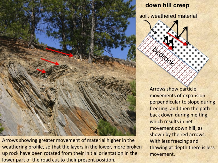
Example of soil creep in metamorphic rocks (phyllites) from the Black Hills.

This image is from the town of Longyear, Norway on the Arctic island of Spitsbergen. These wooden stumps used to be the supports for some older buildings. The buildings are built above the ground to insulate them from the permafrost below. Note how they lean downhill. This is due to soil creep in the active permafrost layer (with abundant freeze-thaw action.

The above image is of a mountain side in Spitsbergen, with over 2000 feet of relief here. Note the conical masses of sediment at the base of the cliff. These are talus cones, and they form by a combination of debris flows and rock falls from the overlying cliffs. Each cone originates from an incision into the mountain side known as a chute. If one looks carefully, a distinct channel with levees exists on the middle and largest talus cone. This is a scar from a more recent mudflow channel. Scars of older mudflow channels are also evident. While it looks steeper here, the talus slope has around a 30 degree slope.

These photos from Yosemite were taken in 2012.

Mass wasting hazard map for Yosemite produced by the USGS. You can see that most of the hazards (the areas in color) are associated with the steep cliffs that lines the glacial valley. It turns out some of the parks facilities were in a particularly high hazard zone, and will be or have been moved. Producing mass wasting hazard maps like this are used for planning and siting purposes. Source: http://pubs.usgs.gov/of/1999/ofr-99-0578/
What is the largest mass wasting event possible on earth?

Map of the big island of Hawaii. Note the areas identified as slumps. These are places where a submarine 'landslide' has occurred in the past. Those that did not creep, but had some portion that slide suddenly may have very well produced tsunamis. Image source: NOAA - http://www.pifsc.noaa.gov/cred/himap/shoals.php

Image above of submarine landslide forms and deposits off the coast of California. Image source: http://walrus.wr.usgs.gov/socal/cabrillo/tierra/submarine_landslide.html .
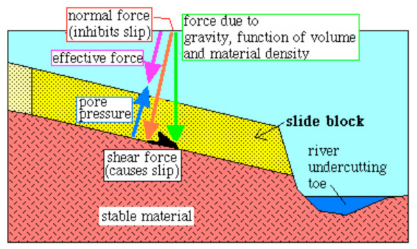
This is a schematic diagram of a potential slide block produced by the erosion of the slope toe by a river, and it helps elucidate the mechanics of slip. The contact between the yellow sandstone and the underlying granite would be a possible slip plane. The driving force is gravity (the green arrow). It can be resolved into its normal and slip components. As the inclination of the slip plane increases the gravitational force will remain the same, but the resolved normal force diminishes in size, while the shear force grows. Friction can be described as the ratio of normal to shear force that produces movement. Also important is the pore pressure which acts in opposition to the normal force, thereby making it easier to slip. This is why surfaces inclined at only a few degrees can slip - they are weakened by high pore pressures. Some type of question on these mechanics and this diagram will be on the test!
The best predictor of future behavior is past behavior.
Recognition of past occurrences or the right situation:
Human activity can induce mass wasting in an area that has been historically stable.
Slope stability analysis - what is strength and what are forces acting on slope material.
Cretaceous Pierre shale: low strength and very prone to mass wasting, widespread in upper midwest.
Can mass wasting be prevented and/or mitigated?
There are a variety of approaches that are used on a regular basis:

Image source: United States Geological Survey (USGS), 2005. Real-Time Monitoring of an Active Landslide above U.S. Highway 50, California. Retrieved on 25 February, 2006 from http://landslides.usgs.gov/monitoring/hwy50/index.php.

![]()
Left: Example of debris flow catchment structure in California. Note that there is an outlet for the water at normal low flows. Right: Emptying debris basin and getting ready for the Image source: http://pubs.usgs.gov/of/2001/ofr-01-0144/

 Blackhawk, California:
Mini-field trips: