Earthquakes as an environmental concern
Environmental Geology Lecture outline
Content:

Part of San Francisco after the 1906 earthquake. Look closely to get an idea of the true devastation. Much of it was caused by fire, which fire fighters were helpless to fight because of broken water mains. Image from: http://pubs.usgs.gov/gip/2005/15/
USGS site with data on earthquakes since 1900 that have 1000 or more fatalities.
Basics - Seismology, the science of elastic waves and earthquakes
What are seismic waves and what information
can obtained from their study?
- waves of elastic deformation that propagate through the earth and at the earth's surface.
- can indicate the where, when and how big of an earthquake.
- can also indicate how a fault moved (analysis known as first motion studies).
- can also be used to image the interior of the earth.
IRIS Consortium
information on seismic waves.
Definition of elastic deformation - recoverable (versus permanent deformation).
Types of seismic waves:
- surface waves (Rayleigh and Love waves)
vs. body waves (P and S waves) that travel in interior of the body.
- primary or P waves: type of body wave, fastest, 2 to 7.8
km/sec in a variety of rocks, travels through liquids and solids.
- secondary or S waves: type of body wave, slower, 1.1-4.6
km/sec in a variety of rocks, travel only through solids
- surface waves: slowest, cause major ground accelerations,
damaging and of most direct concern engineering wise, produces horizontal versus vertical movements and asscoiated forces.

Schematic image of seismic waves from USGS website: http://hvo.wr.usgs.gov/volcanowatch/2008/08_02_21.html
YouTube animation of shaking associated with surface waves of the Loma Prieta earthquake along the San Andreas fault system.
Seismometers: devises used to detect, measure, seismic waves.
- traditionally pendulums, dead weights and
springs that respond to ground shaking.
- now these are chips with accelerometers (can get a seismic app for your phone or tablet).
- seismic networks and computers, provide real time information on earthquakes.
- USGS earthquake data.
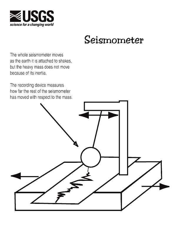
Basic scheme of a seismometer, where earth shaking moves a pendulum which records the movement. Image source USGS website: http://earthquake.usgs.gov/learning/kids/coloring/seismograph.gif
Sources of seismic events:
- earthquakes, fault movements and seismogenic zones.
- magma movement and volcanic explosions.
- impacts.
- waves on the coast.
- assortment of human activity (including nuclear tests).

Example in context of Mt. Ranier seismic network of some of the types of seismic signals they pick up. Note that the different types of events have their distinctive signatures. Image from USGS site: http://volcanoes.usgs.gov/activity/methods/seismic/signatures.php
Elastic rebound model for earthquakes:
- faults show creep (slow and steady)
vs. stick-slip behavior (episodes of sudden movement, i.e. earthquakes), or interesting combinations of both.
- the seismic 'cycle' for stick-slip motion
= bending and storage of elastic energy in the rock along the fault and then sudden release of elastic energy in the vicinity of a "stuck" or locked fault area that tears and becomes unstuck (see diagram below).
- the focus (hypocenter)
as where the tear started and the epicenter as the surface point directly above.


Depiction of elastic rebound model for producing earthquakes. The last stage represents a sudden break and sliding along the fault as the stored elastic energy is released as seismic waves. The photo on the right shows fault offset, although along this section of the San Andreas the fault often moves slowly, creeps, instead of going through cycles of stick-slip. Image from USGS website: http://earthquake.usgs.gov/regional/nca/1906/18april/reid.php
Where was the earthquake located? Located by triangulation
from P vs. S wave delay times.
Virtual seismology link.
How to measure the size of an earthquake?
- Mercalli scale:
a human scale, intensity of damage.
- Richter scale:
energy release from the amplitude of a calibrated P wave arrival. Important aspect is the log scale so that a jump from 6-7 is a ten-fold increase in seismometer release, and about 30 times the amount of energy release.
- Moment scale: function of area that slipped and force involved. A more precise
geophysical determination.
How did the earth move? First motion
studies use the pattern of first ground motions around the earthquake to determine fault geometry and slip direction.

Schematic diagram showing the pattern of first seismic waves that radiate from an earthquake that starts at the focal point center as a function of how the fault moves. Seismologists reverse the thought path, and observe the pattern of first motions and deduce the first motion from that pattern. Diagram from: http://earthquake.usgs.gov/learning/glossary.php?term=first%20motion
What determines the size of an individual earthquake?
- size of area on fault that slips.
- amount of slip
(for larger RM earthquakes in the realm of 8 slip can be 10s of meters in an earthquake event).
- rate of slip.
- frictional resistance.
- these are not independent, so that size of area that moves scales with the amount of slip.
- largest size possible?
Earthquake prediction
Desirable aspects to predict?
- location.
- size.
- specific time.
- statistical likelihood of a given size in a given area (usually expressed as a recurrence interval for a given size earthquake).
- local response.
- maximum magnitude earthquake for an area.
We can do fairly well with all of these except specific time.
Future location and size of earthquakes
(neglecting time component):
- plate setting, historical record, based on microseismicity (where there are little ones there could be big ones).
- Meers fault in Oklahoma as cautionary tale (seismically quiet).
- identification of active faults by geomorphic
signature and trenching (e.g. Kerry Sieh, Pallett
Creek and the San Andreas).
- paleoseismic indicators (liquefaction
features and tsunami deposits, e.g. W Washington).
- maps of past seismicity identifying seismic gaps and locking geometries.
Estimate of statistical likelihood is based on the previous history of earthquakes. A log-log frequency-size relationship exists that can be used for this purpose.

Conceptual slider model used for understanding the array of different size earthquakes that can occur along a fault surface and the log-log frequency-size relationship that exists.

Map showing New Madrid seismic zone, an area inside the North American plate that in 1811 and 1812 produced three very large earthquakes. Map from USGS site: http://earthquake.usgs.gov/regional/ceus/urban_map/ . Summary of history including 3 large earthquakes in 1811 into 1812 can be found at http://earthquake.usgs.gov/earthquakes/states/events/1811-1812.php#summary .
Estimation of recurrence interval (statistical likelihood):
- you saw this material earlier in the semester.
- Gutenburg-Richter log-log frequency-size
relationship.
- fractals and fracturing.
- e.g. 40% chance of great EQ in southern CA
in next 30 years.
- extending the record with trenching.
- of intraplate EQs such as Nebraska.
- use of these estimates for building codes.

Plot for area 1000 km radius around 2004 Sumatra earthquake epicenter (the one that produce the horrific Indian Ocean tsunami). The x axis is Richter magnitude, and the y axis is the log of the number of earthquakes of a given size or more per year. -1 on the y axis is a recurrence interval of every 10 years and -2 is every 100 years. Large earthquakes can be expected on a fairly regular basis in this part of the world.

Early map showing earthquake probability map that successfully 'predicted' the Loma Prieta section that moved. From USGS site: http://pubs.usgs.gov/fs/2003/fs017-03/
Are prehistoric large earthquakes recorded in the geologic record? The general answer is yes, and this is what drives the science of paleoseismology. Since the longer you have a record of behavior for the better one can forecast such information is of value.


USGS scientist looking at recent tsunami deposit in Papua New Guinea. Image source: http://walrus.wr.usgs.gov/tsunami/PNGhome.html . To left is a close-up image of the tsunami layer left by the Papua New Guinea event. Image source: http://walrus.wr.usgs.gov/tsunami/PNGhome.html .

To the right is a tsunami sand found in the Pacific northwest (with a large earthquake producing subduction zone just off shore). An earthquake that would produce such a deposit is not known from historic times. What are the implications for cities such as Seattle? Image source: http://soundwaves.usgs.gov/2008/01/awards2.html .
Prediction based on dilatancy hardening
theory and the use of precursors.
- dilatancy in the laboratory: micro-cracking before the big earthquake failure produces a volume increase in the rocks along the fault.
- potential expression of dilatancy as precursors in the field:
foreshocks, surface bulges, changes in water level, changes in
seismic velocity, changes in radon content of water, localized
changes in earths magnetic field.
- Haicheng, NE China prediction in 1976
of 7.3 RM EQ, 10% success rate claimed in China.
- overall success questionable?
Cost of a precursor monitoring program?
A successful prediction vs. a successful
track record: The interesting case history of the Jupiter
effect, Iben Browning and the 1990 prediction for New Madrid seismic zone:
- New Madrid area is along the Mississippi River in the lower Missouri area, where in 1811 and 1812 there were 3 very large earthquakes (USGS account).
- these are intraplate earthquakes, spatially associated with buried old faults (rift related faults).
- this area a focus of seismic risk and a lot of research.
- USGS account of the prediction.
Geohazard risk elements during and after an earthquake
What happens during an earthquake that can produce risk? As the diagram below suggests it can be fairly complicated. This doesn't include the permanent shift of the ground that can occur along a coast so that structures become submerged.

Thought path diagram for risk elements from an earthquake.

1964 Good Friday Alaska earthquake, downtown Anchorage – subsidence produced by mass wasting. Here it is in the process of being repaired. There are many more examples of mass wasting events triggered by earthquakes that caused loss of life and damage. Image source: http://libraryphoto.cr.usgs.gov/cgi-bin/show_picture.cgi?ID=ID.%20Alaska%20Earthquake%20no.%20%20%20%2045ct

Destruction at Port William from 1964 Alaska earthquake tsunami. Image source and information on other tsunamis that have hit the U.S. can be found at: http://soundwaves.usgs.gov/2005/01/fieldwork2.html .

Fault scarp and unfortunate house directly astride the surface rupture during the 1959 Hebgen Lake earthquake. Image source: http://earthquake.usgs.gov/earthquakes/states/events/1959_08_18_pics_1.php
Amplification by thick wet sediments (like jello) is an important consideration and played a major role in the 1985 Mexico City earthquake.

Diagram showing the different ground movement responses to the Loma Prieta Earthquake of 3 stations close to each other. The amplitude of the seismic trace is a function of the earthquake size, of the distance from the earthquake center, and of the type of substrate. In these responses the earthquake size is constant (since all traces are for the same earthquake, and the distance from the earthquake center is not greatly different. Most of the difference is because of the substrate. Water and clay rich sediments can amplify seismic waves tenfold or more. Image from USGS site: http://earthquake.usgs.gov/regional/nca/qmap/ .
Liquefaction: when shaking by earthquake waves causes sediment with pore water to turn into a mobile slurry with no strength that can move around and thereby cause damage to overlying structures.
Aftershocks - smaller earthquakes that occur on the fault after a larger earthquake:

Dots represent aftershocks for the 2011 Japan earthquake. The cluster of earthquakes basically represents the area along the fault surface (a subduction zone under Japan. Note the very large footprint, which is why this was such a large earthquake. Image source: http://earthquake.usgs.gov/earthquakes/seqs/events/usc0001xgp/
Injection and reservoir induced seismicity
Just as with sliding along a surface during mass wasting is influence by pore pressure of the fluids in the ground, earthquake behavior is also influence by the same basic physics. It has been a well known fact that injection of fluids into the ground can cause earthquakes.
Why do we inject fluids into the ground?
- to get rid of fluid waste water, including salty waste water produced during oil and gas production.
- fracking (not established that this produces earthquakes and unlikely that it does so given present understanding).
- solution mining (e.g. for salt, and for Uranium in NW Nebraska>
- for geothermal power production (in some cases, not all).
Additional information:
- Temporal and spatial association with injection activities demonstrates they are injection related.
- Primarily smaller earthquakes, but up to R.M. 5.6 (Prague, Oklahoma) causing some minor damage in the area). No theoretically limit to the size.
- dependent on injection depth and volumes with deeper and more increasing chances of induced earthquakes.
- USGS site on induced earthquakes - http://earthquake.usgs.gov/research/induced/ .

Cumulative frequency plot of earthquakes in central U.S.. In such a plot a line represents a constant rate. One can see the clear departure from a straight line starting in 2005. One suggestion is that change is due to the concurrent increase in fracking operations in the area. However, the USGS has connected the increase to deeper waste water injection that is associated with oil/gas production waste waters. Image source: http://earthquake.usgs.gov/research/induced/
Reservoir induced seismicity is associated with filling larger reservoirs, likely due to the new load on the crust and the change in pore pressure, and may diminish with time.
Click here to go on to earthquake engineering.
Return to Environmental
Geology course index.
Return to Harmon's
home page.