 Lab objectives:
Lab objectives:
General motivation for the lab: Reading and compiling geologic maps is a basic skill in geoscience, and this lab is designed to start developing your geologic map reading skills.
Image to right: Geologic map of California. What can you learn about the geology of California from reading such a map? If you try to capture the explicit and implicit information in this map in words it would be a lengthy document. Maps are very efficient communication devices. Image source: http://education.usgs.gov/california/maps/california_geology1.htm.
Review of map components: map scale, topographic contour interval, magnetic declination, projection, coordinate system (latitude-longitude, UTM), legend.
What types of geologic units might be shown on a geologic map?
What types of geologic contacts might be shown on a map?
Topography, structure, and map pattern: We will learn about these relationships in much more detail in next week's lab.
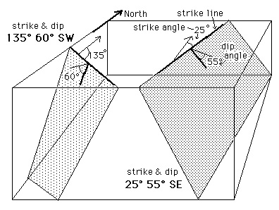
Definition of and map symbol for strike and dip:
Definition of and map symbol for trend and plunge:
Map symbols for simple faults and folds.
Small part of Grand Canyon geologic map taken from http://geomaps.wr.usgs.gov/parks/grcaproj/grcaproj.html. It displays many of the type of map relationships described above (sub-horizontal contacts sub-vertical contacts, a major unconformity).
Some additional interesting sites related to geologic maps:
Part 1 (9 pts.)
Use the provided map (hard copy) of a small part of Spitsbergen (Sørkapp = south cape) to answer the following questions (converse with each other about possible answers, but when drafting your answers you must work on your own). A colored version of the map is available to help (link to color version of map), as is the relevant portion of the map legend (link to legend). Your first should be to familiarize yourself with the map (the topography, scale, geologic units and age relationships, geologic symbols. After having done this complete the following below.
1) Trace with a red pencil the major unconformity shown on the map. Be careful to trace it throughout the map area wherever it exists.
2) What type of unconformity is it (disconformity, angular unconformity or nonconformity)?
3) What is the approximate stratigraphic thickness of unit 13 (contour intervals are 50 meters)?
4) Trace with blue the fold axial surface of the major antiform and synform in the older rock sequence on the map.
5) What direction are the folds in the basement rocks plunging (if you were to follow the hinge zone of a folded surface, the point of maximum curvature, which direction does it go down into the ground)?
6) Are the normal faults steeply dipping or shallowly dipping? What is the map evidence for your answer?
7) Trace the normal fault with the likely largest offset (look carefully) with green.
8) What direction is the structural grain in this area?
9) Draw a north-south cross section sketch from Listefjellet to the coast showing the nature of the major geologic units. First, draw a rough topographic profile sketch. "fjellet" means mountain in Norwegian (as can be seen by the topographic contours also).
Part 2 (11 pts.)
You will each either chose or be assigned a map to work with. Please analyze it as fully as possible for the structural information it contains. Two products should be generated. You are encouraged to help each other with this.
Here are some questions that you can ponder and which may help you analyze the map. The ones in bold should be specifically addressed in your presentation, but you should also address the other questions if they are pertinent.
By answering these and similar questions you should have the understanding necessary to assemble an initial idea of the structural architecture and history of the area.
It is traditional and useful to organize your results into a history from earliest to latest events.
Your presentation should focus on three or so major points about the geologic history that can be drawn from the map. You might put them in historical order. You also need to point out on the map the evidence for your assertions. Five minutes is not much time, and so you should definitely carefully organize your presentation. The objective of your presentation is to educate the other students about the structural geology and history of your assigned map area.