
Lexcture Index:
Common mineral components in sedimentary rocks:
Photograph of sand grains on a Colorado River sand bar. Most of the light grey and clear grains are quartz. Image source: http://pubs.usgs.gov/sir/2008/5042/ .
What are important factors in classification of sedimentary rocks?
Identification flow chart for sedimentary rocks.
Saga of sedimentary rocks, a tale of 4 parts:
Weathering: the disaggregation and chemical alteration of surface rocks that produces sediment.
Physical weathering: mechanical breakdown due to a variety of 'forces'. What causes rocks to be physically broken down?
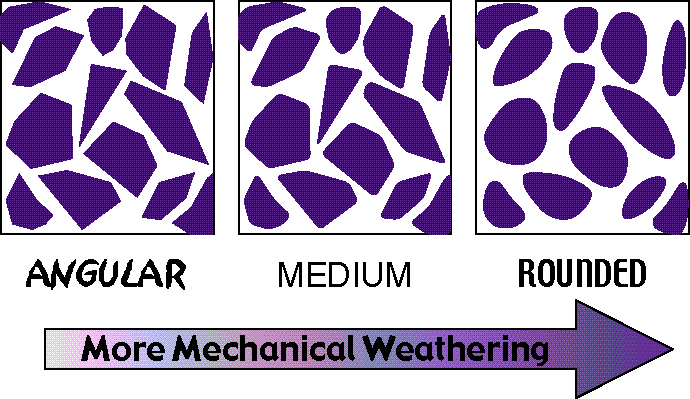
One common source of weathering is abrasion when sediment is being transported in water. This leads to a change in the sediment particle texture as illustrated in this diagram from the USGS (http://education.usgs.gov/lessons/schoolyard/RockDescription.html)

Image from east coast of Baja (Cab Pulmo) of boulder deposit that demonstrates a physical weathering process. The boulders are made of granite, the same as the bedrock seen in the foreground and in the background. The granite was broken up into blocks by fracturing, in part due to tectonic related forces in the crust. When it is exposed by the erosion of the overlying material it is already fractured. Wave action associated with the coastal setting then shapes the granite blocks into round boulders. The smaller bits knocked off make smaller boulders and sand, that was carried away. Obviously the waves seen in this picture are not large enough to have created this deposit.

Close up of the boulder deposit with person for scale. Note how well rounded the boulders are. The ability of waves to move and shape these boulders is an example of one type of physical weathering.
Chemical weathering: chemical alteration in the surface environment, with clays and oxides as two common results.
What are sedimentary transport agents?
Water is the obvious one. Just think of a muddy river like the Missouri that flows right by our city. What are others?
Image to right is of UNO students on a geologic field trip (2016) traversing a dune crest at Great Sand Dunes National Monument in Colorado, a testament to the ability of wind to transport sand. Click on image for a larger version.
Lithification: from sediment to sedimentary rock. What are the processes involved?
Sedimentary structures and the information they contain
The examples below are just a few of a large array of sedimentary structures that can be found in rocks.
 Ripples on modern beach at Cabo Son Pulmo, Baja, Mexico.
 Ripples in red sandstone.
  Cross beds from Valley of Fire Park in Nevada.


 Mudcracks from Precambrian sedimentary rocks exposed in Glacier National Monument.
 Worm tracks in soft beach sands of a Baja beach.
 In hard rock layers in Oklahoma.
  Cruising tracks on slap of Cambrian sandstone in Smithsonian.
  'Worm' tracks on a sandstone bedding surface from the Cambrian Deadwood Formation sandstone in the northern Black Hills.
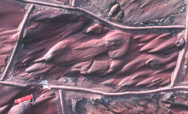
 Sandstones from Toadstool Geologic Park in northwest Nebraska.
Submarine debris flows and turbidites, sedimentation as episodic events.
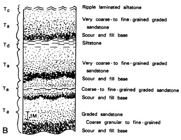

Sketch on left from USGS (http://pubs.usgs.gov/of/2001/ofr-01-0249/FIG11.HTM) showing several stacked graded beds. Each scour and fill base represents the base of a turbidite layer and a submarine debris flow event. Photograph on right of turbidite beds. The thin, darker shale layers represent long periods of time where fine grained mud settled out of the overlying water column, while the thicker light layers represent individual submarine debris flows that were deposited quickly. Image from USGS website: http://earthquake.usgs.gov/learn/glossary/?term=turbidites.
For those interested, movies of modeled submarine debris flows and a whole suite of other movies of sediment transport processes are available at the following website - http://serc.carleton.edu/NAGTWorkshops/sedimentary/visualizations/turbid.html .
The enigma of how submarine canyons are formed. Link to Monteray submarine canyon, source - http://oceanexplorer.noaa.gov/explorations/06davidson/background/geology/media/davidsonmap.html.
Stratigraphy, the description of stacked sediments:

View of different layers in the Grand Canyon. Note the different colors, thickness, and the cliff forming units versus the bench forming units. The layers have been formally divided up into named stratigraphic Groups and Formations.

Diagram of Grand Canyon stratigaphy from USGS web site http://3dparks.wr.usgs.gov/coloradoplateau/grandcanyon_strat.htm . The Kaibab Limestone and Coconino Sandstone are the two lighter colored layers near the top of the layered rocks in the photo above.
Shifting depositional environments and the sedimentary record:

Image of a cliff side from Edgeoya, Svalbard showing what are interpreted to be preserved delta foreset layers that built out from right to left. About 120 meters of exposed cliff section is shown. These strata are part of what was once a shallow Triassic sea where muds and sands were deposited in a variety of coastal and marine environments. Rivers supplied sediment that shoreline and marine processes redistributed and reshaped.

This is a road cut of Cretaceous age strata on the park road into the interior of Mesa Verde National Park in Colorado. The dark layers at the very top are interbedded coals and shales. The somewhat slanting sandstone bodies in the middle part of the layers exposed here are interpreted to be sands that deposited on the inner bed of a river channel (point bar deposits). The channel and the point bar deposit shifted from right to left with time. This is a small scale example of a lateral shifting depositional sytsem. A road marker to the left gives some idea of scale. Click on the image for a larger scale version to see more detail.

Return to Physical Geology index page.
Return to my home page index.