Physical Geology lecture - geophysics
and earth's internal structure
How do we 'see' into the earth and understand what it is made of?
- consideration of densities.
- seismic imaging.
- other.
1) Simple argument of comparative densities that provides insight into earth and planetary structure (all densities given below are in gm/cc which is grams per cubic centimeter).
First, what determines mineral/rock density?
- the atomic weight of the elements that make up the mineral or rock.
- remember Bowen's Reaction Series from lecture before, and the Fe and Mg rich high temperature end of denser minerals (and igneous rocks) and the Si and Al rich lower temperature and lower density end.
- the geometric arrangement (lattice architecture) of those elements.
- remember also the difference between diamond and graphite, both made out of pure carbon. Diamond has a density of 3.52 gm/cc (where cc stands for cubic centimeters) whereas graphite has a density of 2.25 gm/cc.
Relative average densities of rocks in gm/cc:
- crustal material: sediments 2.1-2.8, granites
2.6, basalts 2.95.
- mantle material (mantles is below the crust): peridotite 3.25, dunite
3.25.
- bulk density of earth 5.5.
- how do we know this?
- what does this tell you?
Consider how the earth rotates. What is the relationship between the center of the earth and the rotation axis? What does this tell you about the distribution of density inside the earth?

Objects rotate about their center of mass. If they are internally composed of components of different mass, then you can say something about the internal distribution of mass from they way they rotate.
2) Seismic waves and seismic imaging: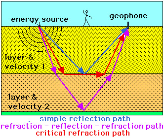
- akin to ultrasound.
- surface vs. body waves.
- P vs. S waves.
- animations showing seismic wave propagation.
- seismic velocities vary due to different
rock/sediment types.
- reflection and refraction occurs at velocity
discontinuities, which are caused by the contact between different geologic units.
- Diagram to right is simple schematic showing how seismic waves propagate from an energy source (such as an earthquake), and how you can trace part of the radiating seismic waves with wave trace arrows, and how different paths (shown in different colors) occur. By listening at the surface with geophones (and/or seismometers) one can work out where the boundaries are that cause reflection and refraction and in this way one can image the interior of the earth.
- globally consistent velocity boundaries are seen inside the earth - the earth is layered at a large scale.
- shadow zones and the molten core are formed by the fact that S waves can not pass through liquids.
- seismic anisotropy and tomography.
- seismic anisotropy is where seismic waves pass through a material faster in one direction than another and is usually related to how the lattice structures of the mineral grains are aligned with each other or not. An alignment can reflect how the mantle is convecting.
- seismic tomography is a technique that maps the varying seismic velocity in the mantle by looking at many earthquake records with seismic waves that have passed through the different parts of the mantle. Slightly colder areas have faster velocities, and slightly warmer ares have slower velocities. Mini-lecture that provides some idea of how this works - http://www.youtube.com/watch?v=5ZI9RG7x2lE .
- IRIS - organization for study of the earth's interior using seismic techniques.
- Earthscope - NSF project dedicated to geophysical investigation of North American continent.
- Intro lecture from Berkeley, California that goes into seismic imaging of the earth's interior in more detail - http://www.youtube.com/watch?v=ve7N25R2h4c.
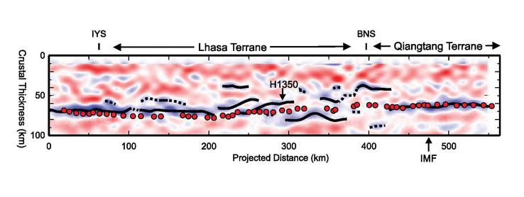
Seismic image showing the Moho (the crust-mantle boundary) beneath part of the Himalayas and Tibetan plateau. There are different ways we can image the crust- mantle contact, which are shown here as dark lines (reflections), colors and red dots. Here the continental crust is thicker than normal because of the mountain building that resulted from the northward plate movement of India into Asia (more on that later). In addition, it is possible that the crust mantle contact is deformed here because of the plate tectonic movements. Credit: Tai-Lin Tseng, University of Illinois, Wang-Ping Chen, University of Illinois, Robert L. Nowack, Purdue University/IRIS Consortium Other images like this one can be found at the IRIS gallery page.
3) Other types of data to use in constructing
a model for the interior of the earth?
- far traveled mantle xenoliths.
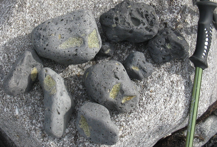
- pieces of the mantle are carried up to the surface by magmas that ascend from the mantle and erupt at the surface.
- Image to right is of basalts with ultramafic mantle xenoliths (the green granular fragments in the basalt ) which are composed of the minerals olivine and pyroxene. The basalt pieces are rounded because they are now part of a beach deposit. You can note the vesicularity (the gas bubbles) in the basalt. Just up the slope is a young cinder cone in northwestern Spitsbergen, that these basalt pieces came from.
- meteorites:
- leftover material the earth originally formed from.
- interior pieces of broken up planetary bodies that differentiated into core and mantle.
- Some images of meteorites.
- behavior of magnetic field:
- large wavelength gravity anomalies from deep sources.
- isostasy: the idea that the upper level of the earth (crust/lithosphere) floats - indicates ability to flow and deform as a very viscous fluid-like material (a rheid).
- theoretical studies of phase changes in
P-T space.
 Models for the large scale structure of
the earth:
- compositional boundaries and layers: crust
- mantle - core
- Moho and
crust/mantle boundary at 30-70 km for continents and 5-15 km
for oceanic crust.
- Discovered by Dr. Andrija Mohorovii (Moh-ho-ro-vee-chich), pictured to the right, a professor of meteorology at the University of Zagreb. Photo source and more information at USGS site : "The layered Earth turns 100 years old" http://hvo.wr.usgs.gov/volcanowatch/2009/09_10_22.html .
- mantle vs. core contact at 2900 km, much
more interesting and complex than thought before.
- these three layers are due to differentiation - heavy material "sank" to form the core, the light material rose to form the crust, and the mantle remains in between.
- mantle phase change boundaries.
- lithosphere-asthenosphere boundary (contact between the plate and underlying convecting mantle material) at roughly 70-150
km depth - below this level conditions create a small percent partial melt
in mantle material that weakens it considerably. Boundary known
as LVZ (for low velocity zone) because seismic waves travel a little bit slower.
- circa 400 km there is an olivine to
spinel mineral transition and a marked density increase.
- 670 km there is a spinel to perovskite
mineral transition boundary between upper and lower mantle, that is thought by many to separate one convection pattern above from another below (stratified convection).
- liquid outer core
and solid inner core at 5100 km depth.
- Core is composed
primarily of iron with some impurities.
- Rapid convection in outer
core creates a magnetic dynamo affect that produces our magnetic
field.
- With time inner core should be getting larger, releasing heat as it does so.
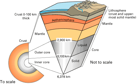
Image from USGS that summarizes larger aspects of earth's internal structure. From USGS site: Inside the Earth, http://pubs.usgs.gov/gip/dynamic/inside.html .
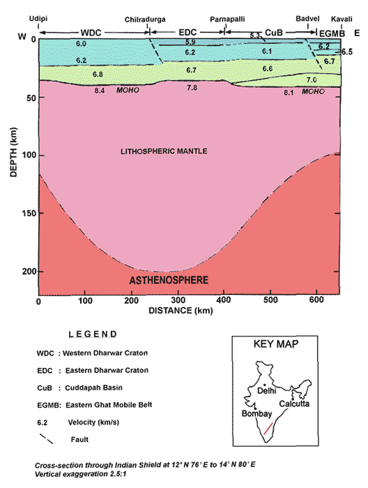
Model showing crustal and plate structure as deduced from seismic imaging for part of Indian continent. The blue versus the green is the upper versus the lower crust. Image source from USGS site: http://earthquake.usgs.gov/research/structure/crust/india.php .
Mantle convection:
- two fundamental modes of heat transfer - conduction and convection.
- lines of evidence that interior convection
goes on inside the earth:
- processes of seafloor spreading and subduction (discussed in great detail in upcoming lecture)
where crust forms from and then is recycled into the mantle.
- hot spots - areas of concentrated volcanism
located above mantle plumes.
- physics that suggests under mantle conditions
the rocks can convect.
- overall driving force is gravity. Convection
is in response to density differences and buoyancy forces due
to temperature and phase changes.
- does interior convection drag the plate
above about, or do the plates do their own thing and thus influence
underlying mantle convection?
- convection movies from Caltech.
- Los Alamos convection movies.
A bit on comparative planetology.
Harmon D. Maher Jr. reserves copyrights to
the materials in this site. Material may be used for non-profit
educational purposes as long as proper attribution is given. For
permission for any other use please contact author. Thank you.
Return to Physical
Geology index page.
Return to my home
page index.
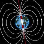 Image from: http://spaceplace.nasa.gov/spaceweather/en/