Physical Geology Lecture - Plate
boundaries and associated geologic activity.
Classification of plate boundary types (bit of review plus expansion):
- There are two major factors used to classify plate boundaries: 1) how the plates are moving relative to each other, and 2) the type of crust and lithospheric mantle that makes up the plate (basically oceanic plate material versus continental plate material versus terrane type material. We can then use a matrix to identify the various types of plate boundaries and there traits.
- Divergent:
- continental rifting, for example the EAR (East African Rift).
- seafloor spreading, for example the MAR (mid-Atlantic Ridge) with Iceland as an anomaly where
the rift is exposed.
- Convergent:
- subduction zones,
where oceanic crust is recycled into the mantle, for example the Andes
- terrane accretion,
where a terrane such as an arc is added to the active margin.
- collision zones,
where continental fragments collide, produce a mountain belt
and close an ocean basin.
For example the Himalayas.
- Transcurrent:
where two plates slide past each other. For example, parts of
the the San Andreas system.
- Intermediates (with oblique motion components).
- transpression:
oblique motion with dominant boundary parallel motion, but with
a convergent component.
- transtension:
oblique motion with dominant boundary parallel motion, but with
a divergent component. For example the Dead Sea Transform in the Middle East.

Map summarizing some of the major plates and plate boundaries. You might practice locating examples of the different types of plate boundaries mentioned above. Image source: http://vulcan.wr.usgs.gov/Glossary/PlateTectonics/Maps/map_plate_tectonics_world.html
In-class exercise: Develop a classification structure from the intersection of two different sets of classes similar in form to what we explored in class for plate boundaries, but for some other phenomena. The classification can cover any realm, but naturally one that is of interest to you (perhaps related to your career interests) will work best.
Now on to some details.
Subduction-arc complexes - recycling oceanic crust:
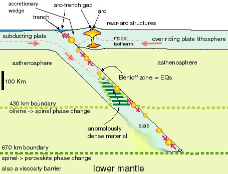
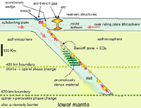 review - site of arc volcanism in the overriding plate,
and of a deep trench (up to 12 km below sea level) that marks
the boundary.
- surface elements: trench, inner
and outer trench walls, arc-trench gap, arc,
rear arc basins or fold-thrust belts (click on adjacent diagram).
- Benioff zone:
This is a zone of earthquakes that in 3-D defines a surface that
slants into the mantle to depths of 670 km. It represents the
colder top of the subducting oceanic lithosphere. There is debate
as to the exact mechanisms that produce the deep earthquakes. They
must be different than those that produce shallow earthquakes.
- accretionary wedges and melanges: melange (meaning mixture) is
composed of blocks of basalt, limestone, serpentine, gabbro,
blueschists and eclogites (and more) that are embedded in a highly
contorted mess of sedimentary rocks, including deep marine oozes
and volcanogenic sediments. This collects above the descending
plate as an accretionary wedge, and can be thought of as the scrapings.
- a chain of thought: large, deep positive
gravity anomaly over the subducting plate can be related to phase
and density changes in the mantle, which in turn suggests the
mechanism of trench pull.
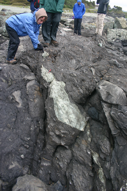
UNO students studying Fransiscan melange along the northern coast of California (near the city of Crescent). Note the lack of continuity of layers and features due to the severe deformation this rocks suffered when they were part of a subduction accretionary zone.

Schematic diagram of subduction and spreading ridge off the the coast of Oregon and Washington. Image source - USGS, http://vulcan.wr.usgs.gov/Glossary/PlateTectonics/Maps/map_juan_de_fuca_subduction.html
Mountain building - collisional processes
and complexes:
- Wilson cycle framework: basic idea is that oceanic basins open, grow and
then close more or less along lines of previous closure.
- arc and continental crust is nonsubductable,
so plate impingement must be produced by other processes. Such crust is non-subductable
because of lighter density, greater thickness, and weaker character.
- four major processes involved in forming
mountain belts:
- accretion of exotic and suspect terranes: occurs during subduction. you might think of this
process as accreting extra large piece of nonsubductable type
material.
- crustal thickening: primarily by folding and faulting (will talk about
next lecture). The crust beneath the Himalayas and Tibet is about
70 km thick, double the normal thickness.
- escape tectonics:
fault bounded wedges shoved out of the way to the side. Himalayas
as the example.
- gravitational collapse/spreading: mountain can only grow so high, and when the roots
collapse they spread out similar to the way an ice cap spreads
out.
- Himalayas, Appalachians, Urals, Alps: as some
of many examples.
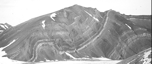
Folded and faulted Mesozoic strata in Spitsbergen, Norway, exposed in a glacial valley wall - simple visual evidence of local crustal shortening.
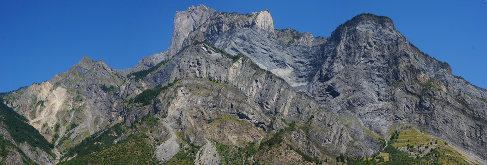
In this cliff side in the French Alps one can see the tilted sedimentary layers once in the marine realm (e.g. limestones), and a close look shows a recumbent fold in the very middle, the details of which can be seen in the photo below. The Alps formed through a complicated history of small plates and terranes moving northward into Europe as a larger ocean closed to form the present day Mediterranean. The Alps where were some of the earliest studies into tectonics occurred, and this mountain side is an example of why.
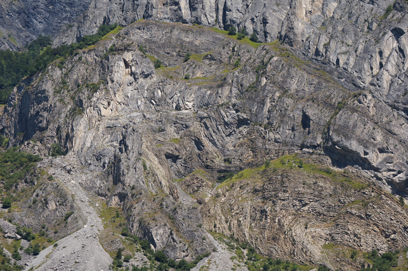
This is a more detailed view of the core of the large fold above, displaying what might be considered rather extravagant folding. Folding such as this is one of the major mechanisms of crustal thickening seen in mountain belts.
Transcurrent tectonics:
- complexities from locking and releasing
bends:
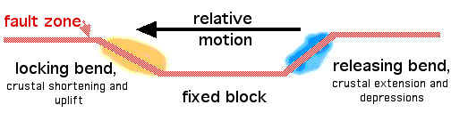
- San Andreas as an example.
Supercontinents:
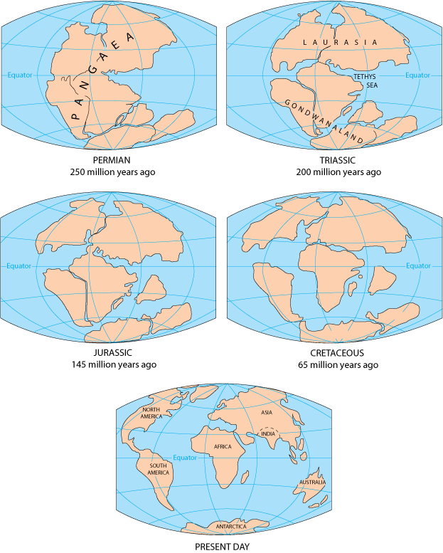
Diagram from USGS Dynamic Earth site showing a simplified reconstruction of continental configurations through time. Site source: http://pubs.usgs.gov/gip/dynamic/dynamic.html .
Hot spots and mantle convection:
- classic example is the Hawaiian chain of volcanic islands and seamounts.
- since the basalt is a 10-20% extract of the mantle source, much more mantle material must be moving upwards underneath as a rising column, which is referred to as a mantle plume.
- plates move relative to these semi-fixed mantle plumes suggesting a different convection pattern associated with the plates (likely more shallow) than those with the plume (likely deeper).
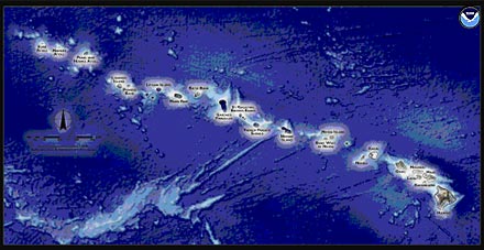
Map from NOAA showing the linear chain of volcanic islands and seamounts with Hawaii at the end. Source: http://coris.noaa.gov/about/eco_essays/nwhi/archipelago.html
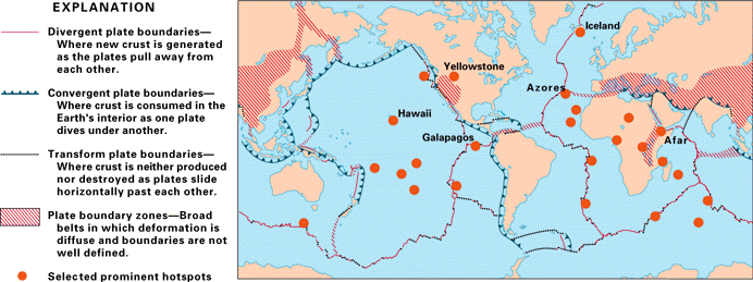
Image from USGS Dynamic Earth site of major hot spots in the world. Notice the proliferation of hot spots in Africa.
Link to course material for Plate Tectonics course.
USGS Dynamic Earth - description of the Plate Tectonic paradigm.
Harmon D. Maher Jr. reserves copyrights to
the materials in this site. Material may be used for non-profit
educational purposes as long as proper attribution is given. For
permission for any other use please contact author. Thank you.
Return to Physical
Geology index page.
Return to my home
page index.
 review - site of arc volcanism in the overriding plate,
and of a deep trench (up to 12 km below sea level) that marks
the boundary.